riverscape

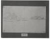
Maximilian mentioned in his journal entry for May 15 that the Yellow Stone lay still until around four o'clock in the afternoon while its crew endeavored to shift it off a sandbank along the western side of the river channel. Strong winds and contrary currents complicated this procedure, and at one point the Yellow Stone was rolling so badly that, according to Maximilian, Bodmer could scarcely draw.

Banks of the Missouri

Bodmer made several studies in the general vicinity of the Niobrara. This watercolor dated May, 1833 may be one of these, but the precise location of the view is not known. Because of modern water impoundments above and below the mouth of the Niobrara, the original aspect of the Missouri throughout this area has greatly changed since Bodmer's day. Thus identifying landmarks noted by Bodmer is virtually impossible.

Missouri River landscape

The Yellow Stone reached the mouth of the Big Sioux River early on the morning of May 8. Dated this day is Bodmer's watercolor sketch of the confluence of the Big Sioux with the Missouri below present Sioux City, Iowa. Near the mouth of the Vermillion River on May 10, steamer passengers had their first glimpse of a beaver lodge. On May 11 several Indians came aboard the Yellow Stone; they disembarked the following day at the Ponca village below the mouth of the Niobrara.

Mouth of the Big Sioux River

The travelers departed Cabanne's post on May 5 and continued upriver toward the abandoned military post of Fort Atkinson in the vicinity of present Fort Calhoun, Nebraska. Maximilian recorded in his journal that "of the ruins of the fort abandoned here in 1827 there now stand only the walled chimneys, and in the middle a stone storehouse under a roof." Although identified by its inscription as a view of the ruins of Fort Atkinson, Bodmer's study of the river at this point includes no obvious architectural details by which one might distinguish the site.

Ruins of Fort Atkinson

Another of Bodmer's views of the Missouri, dated May 3, describes an aspect of the river four or five miles below the mouth of the Platte. In his daily account Maximilian noted that at this point one could already distinguish the effluent of the Platte "since it is clear and blue; it runs separately along the bank lying to the left of us."

The Missouri below the Mouth of the Platte

The Yellow Stone spent the night of April 28 near Good Sun Island above the mouth of the Nemaha. Then, slowed by low water and another grounding, it made no further progress upstream until May 2. After supper that evening a canoe came alongside the steamer. Aboard was Lucien Fontenelle, described by Maximilian as "in the service of the Fur Company. He lives on the post where Major Dougherty owns a house when he travels among the nations of the Otos, Omahas, and Pawnees as Indian agent." The Yellow Stone tied up for the night a short distance below the mouth of the Platte.

The Missouri in the Evening

According to Maximilian, the Yellow Stone passed the mouth of the Nemaha River on the morning of April 26, although a dim pencil sketch by Bodmer inscribed as having been made at or near this juncture is dated two days later. Inscriptions on Bodmer's sketches may in some instances have been added later, or Maximilian himself may have been confused.

Confluence of the Grand Nemaha River

Past the mouth of the Muddy River above Hanging Dog Island on the afternoon of March 21, the travelers approached a feature known as the Grand Tower and, near it, the Devil's Bake Oven. Maximilian described the tower as an isolated, drumlike formation between sixty and eighty feet high. Of the Devil's Bake Oven he wrote, "On the right bank just opposite ... there are three or four very strange rocks full of fissures and ravines... . The front one is called the Devil's Bake Oven. ... At the Bake Oven stands a nice farm house.... (Mr.

Grand Tower and Devil's Bake Oven

The Yellow Stone spent the night of May 3 anchored in the river below Bellevue. On the morning of May 4 the steamer departed upriver toward Council Bluffs (not to be confused with the modern city of Council Bluffs, Iowa)-a well-known landmark on the Nebraska side of the river above present Omaha. Despite recent rains the water level was low, and Maximilian reported in his journal entry that the Yellow Stone knocked against several sandbanks lying just beneath the surface.

Missouri in the Morning below Council Bluffs

The Yellow Stone reached the mouth of the Nodaway River on the morning of April 25. Woodcutters landed at Nodaway Island to obtain a supply of fuel, and Bodmer and Maximilian went ashore to gather botanical specimens. They discovered in the forest a pair of abandoned frame shelters that Maximilian surmised had probably been made by the Sauks or Iowas. In describing Nodaway Island, painted by Bodmer this morning, Maximilian wrote that it was "large and beautifully wooded. Before we reached it, we saw on the right ... the loveliest blooming trees, particularly redbuds."

Nodaway Island

Pages