April 13, 1833
13 April: Early in the morning, beautiful, clear weather, but cool. At 8:30, nice and warm; earlier, slightly overcast sky. We set out at dawn. About seven o’ clock we found ourselves at a very broad, beautiful place in the river. To the left, a row of undulating hills with forest. The entire terrain up to now was heavily undulating and hilly. Several islands and a sandbar in the river. Beautiful view before us. Behind us we have Otter, or L’ Outre, Island, a large island with cultivated fields. To the left, a creek. We sail along the left bank with wooded hills where individual trees are blossoming: sugar maples, cottonwoods, hornbeams, and several others, all of them still without foliage. A pretty creek to the left; the trees are turning green; trunks lie crosswise over the creek.
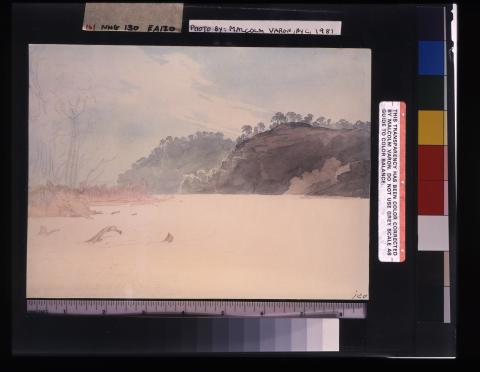
Before us we had a beautiful view into the region of the Gasconade River: many broad sandbars; to the left, scenic hills; various gradations of woodlands; brightmorning bright morning sunlight over everything. To the left, an island; on its surface one sees a 6-foot-thick layer of soil, with sand underneath. A beautiful scenic chain of hills to the left, [with] receding domes [and] valleys, all covered by tall forest where now the trees are turning green. Discounting the appearance of its vegetation, this landscape has a similarity with some Brazilian rivers. Before us, a nice wooded island[Page 2:11], which we leave to the right. There are an estimated 10 miles between L’ Outre Island and the Gasconade.
After breakfast we halted at the left bank near a settlement (at 7:30, 5°R [43. 3°F, 6. ">3°C⟩) [and] took in wood. M16And botanized.Here ironwood, the sugar tree, redbud, spicewood (almost done blooming), a beautiful violet phlox, a blue viola without scent, the fork-shaped flower ([— —]), Claytonia virginica, and several additional plants were  in bloom. Mr. Bodmer saw nothing but squirrels and woodpeckers, and therefore he did not bring back any animals.
At eight o’ clock we move on. Beautiful, bright sunshine. To the left, nice wooded hills; the sugar maple greenish yellow and covered with blossoms. Magnificent, majestic river. To the right, significant elevations many white Platanus in the woodlands. A striking boulder on the left bank; oak and cedar on it. Beautiful rugged valleys from which creeks gush; their banks are often most picturesque. Sugar maples make very picturesque patches in this landscape. To the left in the forest, we saw a flight of wild turkeys; several shots were fired at them from the ship, but they were out of range. Before us to the left appeared a tall, prominent wooded elevation with rocks and cedars on top, behind which the Gasconade River empties, a pretty, not insignificant stream. It originates somewhere to the south in the state of Missouri, not too far from the sources of the Meramec. It emerges from lowlying hills where many yellow and white pine (Pinus rigida and strobus) grow; these supply St. Louis with boards and lumber. The area around its mouth is picturesque: beautiful tall woodlands with various gradations with wooded hills behind them. It is approximately 100 miles from here to the mouth of the Missouri. Direction of the Missouri now W 7 N. Before us there is again a beautiful view: high hills and limestone rocks, islands, and wooded promontories. Somewhat after 8:30 we are opposite the mouth of the Gasconade River. We proceed, keeping closer to the right bank. Broad, scenic expanse of the river under high limestone cliffs, which are stratified like stone walls. The tall willows along the bank are already rather green. To the right there is a splendid cliff, high and steep with a large hole; above it hover turkey buzzards. Along the bank grow tall cedars, about 50 feet high. No use is made of their berries in this country. At ten o’ clock the direction of the river is W 5 S. A half hour later, a creek that is insignificant opens to the right; soon a second one. Then, on a cleared space of the right bank, we reach the hamlet of Portland, which consists of eight to ten houses; a handsome brick house stands on the eminence.
A little farther on, underneath a high rocky wall, there is a covered area where certain products appear to be made, probably ropes. Here a long, wooded island, which remained to our left, came to an end. Soon the Little-Au-Vase Creek follows to our right. Before us, the splendid, majestic expanse of the water; a low island with sand and willows. Direction of the river at ten minutes before eleven o’ clock: W 6 1/2 S. A quarter of an hour later, on the sandbar off the bank, a herd of cattle before blooming redbuds and trees leafing out in green. How picturesque! They moved off at the sight of the steamboat. To the left, large sandbars with driftwood. After three-quarters of an hour, several islands, on one of which are willows and a stand of tall trees. In the forest to the left, Pavia lutea (buckeye), already very green, grows abundantly. While lunch was being served, many islands and sandbars [passed] before us, several of them covered with driftwood. M17At twelve o’clock noon, 9°R [52.3°F, 11.3°C].
After lunch we reached the mouth of the Osage River, as wide as a large brook, but [it] is really supposed to be a river and more significant than the Gasconade of a large brook to the right called Big Mud River; it empties into the Missouri at an acute [Page 2:12]angle. We proceeded for a long time along the right bank and then moved away from it to the middle of the river, where [there was] a large, flat sandbar to the left with many logs. On the sandbar there were several flat willow islands, which, however, are islands only when the water is quite high. In this region the right bank is flat, the left one rounded off; wooded hills are separated by ravines or valleys. Here we ran onto wood or a sandbar, for much black debris immediately drifted away. Soon afterward we suffered a second jolt; the boat tipped somewhat to one side. Ten minutes after one o’ clock, the direction of the river was W 3 S.
After about twenty minutes, a wooded island with sandy shore to the right; facing it, the Osage River, a beautiful and powerful brook, emerges from high banks with tall woodlands. It is said to have two outlets and to have a stronger current than the Gasconade. In the forests on the hills and along the bank, the sugar tree is blooming everywhere and is completely colored a light yellowish green. On the northern bank of the outlet, [the one] which we saw, there was a cultivated field. Farther on, many snags in the river along this bank. Twenty paces away from the ship a coot (Fulica) flew up. To the right, a big sandbar; to the left, a rather small island; another island to the right. The river—that is to say, its left channel—flows in the direction S 4 W. There are several islands here.
To the right appears a wooded hill with several houses before it; this is Cote Sans Dessein, an old French settlement. Here there are now about six houses together and two more detached ones farther up. During the war in 1815, a house here was stormed by fifteen Indians; a man, who was helped by several women, defended it so capably that the enemy could not harm him. M18An exact account of this event can be found in Major Long’s Voyage, vol. 1. Earlier there was a significant town (Cote Sans Dessein) here, but the river consumed it along with the bank. Captain Bennett, our skipper, lived in the isolated house. A boat was sent to bring him and his wife on board. He brought along two small halfbreed children, whom he is rearing. On the opposite side, along the left bank farther inland, live many Frenchmen and half-breeds, who are descended from the Osages.
To the right of Cote Sans Dessein, the houses of which have disappeared, several houses bear the name Alexandria. Another house higher up bears the name Mexico.
While they were fetching the captain, we put in at the left bank, and we collected plants in the nearby forest, in which there was a farm. The plants we found this morning grew here, and also another bulbous plant ([— —]), which people here call Adam-and-Eve. Usually it has two connected bulbs, and people say that, if it is thrown into the water, one bulb floats and the other sinks. These bulbs are said to provide a good medication for wounds. The flower was just opening up. Several kinds of oak were also blooming here, but too far up in their crowns [to see].
Half an hour later we move on. Several big sandbars in the river. To the left, the outlet of a creek, perhaps Wiers Creek. Sandbars and snags to the right in the river. On the creek bank, a boulder on which cedars grow. Somewhat farther on, a little river, Moreau MoreauRiver, empties from the left side. A quarter of an hour from here cedar trees of considerable height grow on the right low-lying wooded bank, a rare occurrence. About an hour later the capital of the state of Missouri, Jefferson City, appears on the left bank; it is a village or market town of about one hundred[Page 2:13] scattered houses, but with several rather nice ones of brick. This is the seat of government for this state, and the home of the present governor, Dunklin, rests on the eminence, its front facing the river. It is not large [but] has five windows on the second floor and, on the first, two on each side of the door; it is made of brick and has green blinds. Several additional attractive brick houses can be seen from the river. The three hills on which the town, begun about ten years ago, is situated are crisscrossed with fences, and the stumps of felled trees are still standing everywhere. As we approached the town, two cannon were fired, and on the elevations the population stood in a group before the homes as the Yellow Stone hurriedly steamed past.
A quarter of an hour later we had a very beautiful view to the rear with the sun already close to the horizon, for it was 5:30 when we reached Jefferson [City]. The wooded hilltops on the bank were picturesquely illuminated, and the broad surface of the Missouri shone most splendidly. After supper we passed Cedar Creek to our right. To the left we had an island beside us. We continued until dusk and then put in on the right bank, where we saw a high fire blaze up on the eminence. Wood was taken on here in the dark, and we went into the forest toward a nearby house. I did not quite reach [it], however, [and] returned instead and added entries to my journal. We remained there for the night.

