April 12, 1833
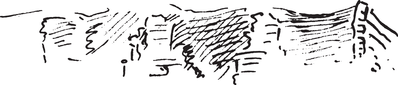
12 April: In the morning, very cool, overcast sky, moderately strong wind. M11Temperature of 3°R [38.8°F, 3.8°C] at 7:30 and 7°R [47.8°F, 8.8°C] at noon. Isle au Bon Homme in the background. To the right, limestone hills with rock walls and covered with forest; on the rocks, the same cedar tree that appears along the Ohio. Once again some of the rocks have the shape of a tower; soon the hills recede; before them, woodland with tall trees. Directly before the river, a fringe of cottonwoods; in the river and along shore, snags in large number. Several islands, also sandbars. To our left there is now an island with cottonwood and willow. We sail to the right through a channel about 150 paces wide. To the right, behind a cultivated field, the row of limestone walls rises precipitously like an amphitheater; it has horizontal streaks. On the bank, Sambucus shrubs already very green.
After breakfast we find ourselves almost at the outlet of a river arm or brook that cuts off an island, where the river is full of branches and logs—this on the right bank. The river has high banks with forest and a fringe of cottonwoods. Again to the left, an island. Right and left, snags in the river. Individual green trees everywhere in the forest; these are sugar maples, which are the first to turn green.They look like beech trees in Germany, with a light-green color as over there. Now there are also steep walls of limestone hills to the left. Soon they become very interesting.
To the right the bank is flat and wooded everywhere. As on the Mississippi, the rocks form round tower shapes and tall, ascending pinnacles, like old ruins.


Some of these rocks are separated into distinctly individual turrets. Some of the valleys between them are filled with green trees in young foliage.
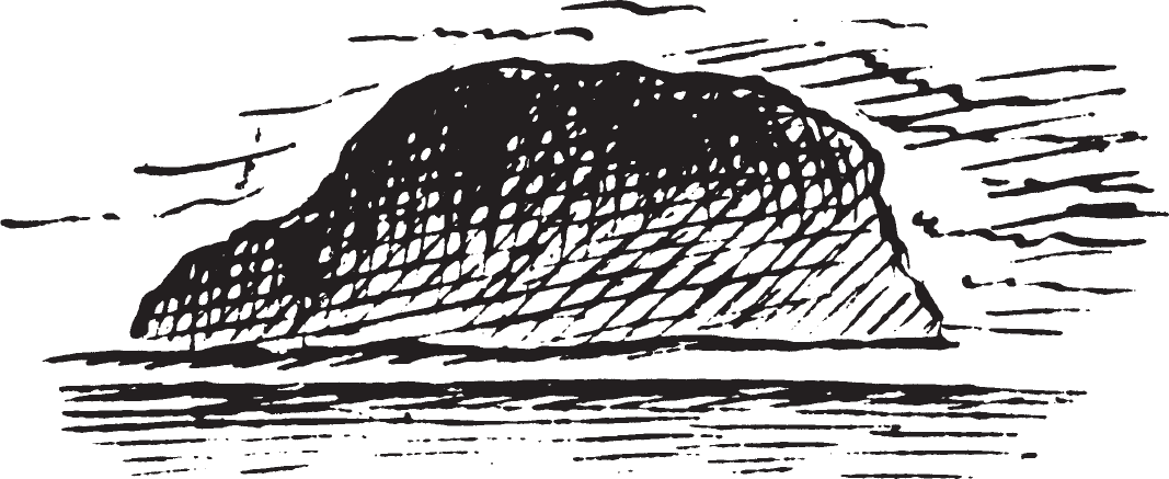
Somewhat farther on we reach Tavern Rock, or Taverne de Montardis, two rocks down near the water. Between the two of them, a small notch with a tree. The first one forms a significant overhanging hollow with sand near the water below, where we find protective shelter for the night. Cedar trees grow on these rocks.
About a mile farther, there was a settlement on the left bank with a large orchard of peach trees, all of which had the most beautiful blossoms. Somewhat farther on, several strangely shaped boulders, including one at the top of the hill that formed a perfect table on a narrow base. This region

is known to the engagés, or French Canadians, as Lève-cul, because the current is so strong here that they have to pupush vigorously with poles when they navigate upstream. The limestone hills are hidden by woodland; to the rear we have a scenic view of the wooded elevations and the beautiful river. The hills have interesting edges and shapes as well as domes; one sees the tall forests all around; sandy islands, their banks steeply eroded; to the right in the forest, light green and purple as well as dark rose-red trees (redbud). The wind is brisk, cool, and contrary. Beyond the hills and to the left there is now a low-lying region; here one does not see the hills—they are hidden by cottonwood forests. Single, treacherous snags lie here and there in the stream.
We sail close along the right bank, which is steep and 20 feet high; a farm here. Farther on, to the right again, more limestone hills; there are naked streaks of rock on them. Redbud paints the woods beautifully red. Lone habitations stand on several isolated limestone hills in the forest. We steer over to the left bank and rapidly sail along it upstream. There are several settlements here and cultivated fields where there is always firewood stacked. At one such place, we saw fine slender, lop-eared hunting dogs similar to the German hound. Beautifully light green and blossoming trees, white (plum trees) and red (redbud). In the river, an island with willow and cottonwood. To the left, deposit of driftwood. From the young engagé who has been rowdy lately, I bought the Blackfoot scalp he was carrying for a. He had been wounded by one of those Indians. M12In the back and was lame. The wiwind drives the sand from the sandbars high up into the air.
This morning Major Dougherty gave me the following information about Indians of the Missouri, the western wilderness, and the Rocky Mountains. The Hidatsas live in three villages near the Mandans, from whom they received their name. The Mandans live in two villages. The French call the Hidatsas Gros Ventres; they call themselves Belantsia or Bellantsië (‘e’ pronounced short). M13As will be demonstrated more in detail in the third volume, this is completely wrong. The Crows (Corbeaux) live near the mountains southwest of the Blackfoot and probably have one thousand warriors. The celebrated Petalesharo, known from Long’ s voyage, died of illness, like his father, Lateleseha. Another chief named Petalesharo went crazy and disappeared. The former was the father-in-law of Little Chief of [Page 2:8]the same nation, who was killed by the Kansa, as they are called by the Americans, or Cans, as they are called by the French (they call themselves Kånzä). The Pawnees consist of four bands: the Pawnee-Loups, Pawnee-Republicans, Grand Pawnees, and Pappage Pawnees. The Otoes and Missourias are now mixed. The latter speak the language of the Otoes (the same words but with a different accent). Otoes [The] Omahas, Poncas, Osages, ⟨[and]⟩ Kansa speak the same language also the Iowas speak it. The Quapaws, too, are said to be from the same to speak the same one. The Comanches and Aïtans live in the Spanish region The more northern peoples—the Sioux, Assiniboines (they speak the same language), Arapahoes, Chians (or Cheyennes), Kiowas (in German, Kayaüä), Blackfoot, Crows (they call themselves Apsarukä)—differ greatly from the former in their customs and practices, M14Here the Comanches and Aïtans should also be men- tioned. They live in the Spanish region. for they do not plant corn and just pursue the herds of buffalo and deer. The Gros Ventres [Hidatsas] are like the Pawnees, Otoes, and Omahas in that they raise corn. The Sioux and related tribes, who live exclusively from hunting, do not shave their heads. On the contrary, they let their hair hang down long, and often they wear artificial hair from forequarters of buffalo or from their slain enemies. They attach this hair to their own with pine resin. Since they have no wax, they use pine resin as the Brazilians use wax. In September the Pawnees, Otoes, and Omahas usually return from their hunting expeditions and then harvest the maturing corn. At the end of October, they leave again, hunt during winter, and come back to their villages in March. Then they sow corn and stay until the end of May or middle of June, when they again leave. They take most of their possessions with them. The rest they place en cache; that is, in the earth they make round cellarlike excavations with narrow necks. Into these go wood and straw, the things they want to preserve, and earth on top, which they tread down firmly. One cannot recognize such places, especially since they lay all kinds of things on top of them. The women can find them again, even in snow.
In the woodlands one could see very many white Platanus to the right along the river. Toward noon the forest was already less green than it had been. At 1:30 we put in on the left bank near wooded hills, on which there was a settlement. Here we took in a large load of firewood. Beautiful plants grew on the steep, treecovered hill. The redbud bloomed magnificently, as [did] a dwarf tree apparently belonging to the maple family, brown with very fragrant wood; Claytonia virginica; several other nice plants; and Hydrangea, the leaf buds of which were just opening. We could not go too far but, after lunch, were fully occupied preparing specimens. A beautiful phlox also bloomed at this place.
A half hour later we hastened on and soon reached an attractive settlement with a pretty garden on the left bank; several others followed. In these regions there is not much wildlife left; turkeys and deer are said to be rather rare, since the area is too heavily populated. To the right there was a border of silver-gray cottonwoods in the forest. Much firewood and driftwood. The river forms an imposingly broad expanse. Behind us in the distance, sand flies high into the air. To the left, a wildly beautiful creek empties; the tall timber had fallen down here in wild disarray [and] lay crosswise, one tree on top of the other.
On the right bank behind the willow border, there appeared tall cottonwoods[Page 2:9] as the second forest level, with a sandy bank before it; to the left along the river [were] wooded hills, at the base of which were several habitations, small log huts, smoking; some of the inhabitants were dark brown. On the bank, large amounts of brownish green moss grow on the ground. Here the hill is very steep with towerlike rock walls. To the right, an island. The river turns to the right. To the left there is a channel that cuts off or forms Boeuf Island. It is not any wider than a large creek. Here most of the inhabitants live farther back on the elevations, because it is more healthful there than on the lower riverbank. Here the river sometimes, although not often, overflows its banks, and in the lowlands, marshes and pools then appear; because of the shade of the dense forests, [these] do not easily dry up and therefore produce fevers.
To the right there was a sandbar in the river, a cultivated field nearby, [and] behind it the forest full of tall, snow-white Platanus. Somewhat farther on, the other end of the above-mentioned channel opened behind Boeuf Island; thus, we have now passed this island. This mouth of the channel is clogged with driftwood. To the right, a broad sandbar in the river. Boeuf Creek empties opposite Boeuf Island. Farther away, a cleared spot with sparse timber. Here there is a small village called Pinckney. Lost Creek empties not far behind it; nearby is an island, which remains to our right. To the left the hill is high and steep with forests; in one of its notches, or valleys, is a settlement with several attractive houses. The island is densely overgrown with slender cottonwoods. To the left, the outlet of a creek. On the island to the right, there are large deposits of driftwood.
Somewhat farther on, something broke on the steam engine so that we drifted backward; fortunately, however, there were no snags in our way. The matter was soon repaired, and we hastened forward. We sailed close along the right bank, which was steep here. The forest had many vines here, but [there was] no green foliage on this island; on the mainland behind it, the forest was much farther advanced. Before us, a very beautiful view of the river in the bright evening sunlight. A Frenchman who had gotten drunk yesterday and behaved badly started a fistfight. Mr. Mc Kenzie had him taken away in the boat; despite that, he returned laterthat later that evening. M15Rivière au Berger empties to the left. To the right, limestone hills are rising again in the forest; cedar shrubs are growing on them. This tree with black berries (Juniperus virginiana) is the same one found along the Ohio and Mississippi. It provides the aromatic wood of which pencils are made. It is said to be extremely durable, and posts made from it last sixty years and more in the ground.
A creek with steep banks empties before the limestone hills; the hills extend along its northern bank and form an amphitheater. As in many areas of this river

region, the rock walls are most interesting. Some of them have the round shape of a tower; before them along the river stands the tall forest with tall, slender, shaftlike forest trunks. Here some trees and plants are already green, particularly the underbrush; the redbud looks as though purple had been poured over it. Here there are picturesquely wild spots with vines and wildly toppled broken, crushed timber; dark, rugged ravines and valleys in which the individual trees, already[Page 2:10] green, shine forth picturesquely. The inhabitants stand singly along the bank near their long piles of split wood, hoping for a sale. Sheep graze on the steep hill in the forest; there is a wide pretty island ahead in the river. We sail ahead, close to the

island; it remains to our right. There are many snags here, against which the port side of our ship strikes, but it was built very strongly for these dangerous voyages on the Missouri and is now making its third one. The Fur Company has had another steamboat, the Assiniboine, built for this same purpose.
Along the bank to the right, there was much broken timber before the boulders; it has been broken off by winds, particularly whirlwinds. We soon put in at this bank to spend the night here. After supper we went to the nearby bank, where a high fire of sturdy tree trunks was burning near the fringe of forest somewhat to the right of the fields cultivated [there]. Our Canadians, who had gone into the nearby house, came to the fire to carry on their lively conversation in French. Messrs. Mc Kenzie, Dougherty, and Sanford also arrived soon afterward, and we spent a while here under the beautiful canopy of stars while several persons on the Yellow Stone, the lights of which shone toward us, played a Scottish tune on clarinets. Several shots echoed beautifully in the lofty forest; probably someone was shooting at wild turkeys, something that is often successfully done at night. After we had returned, several gentlemen played a game of cards and I wrote in my journal.

