trees

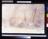
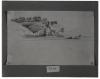
In late November of 1833 Maximilian and Bodmer made a cold, tiring, nine-hour trek from Fort Clark to one of the Hidatsa winter villages to observe a ceremony. They stayed for several days, and this sketch may have been done at that time. Composed of about eighty households, the village is most probably Eláh-sa, the largest of the Hidatsa settlements on the Knife River. Maximilian remarked on the dense arrangement of lodges in the winter villages, where the dwellings were of necessity packed closely together amid the thick, sheltering timber.

Hidatsa Village

On October 30 Maximilian's party left Fort Union and headed downriver toward Fort Clark. On November 4 his journal entry mentions that at some point along the river, the travelers tied up and prepared to spend the night. It reads, "The evening approached. The sky was gray and gloomy and appeared to presage bad weather ... We shipped farther till about dusk and then landed on the right in the forest above the tall, steep bank... At midnight the sky turned clear and the wind cold...Mr. Bodmer had made a drawing of our bivouac last night."

A Stop; Evening Bivouac

Steaming past the Blacksnake Hills on April 24 Maximilian recorded in his journal that the surrounding scenery was "very picturesque .... Mr. Bodmer made a sketch of the chain of hills and of the white trading house . . .. In the house dwell a few men who are in the service of the Fur Company. We stopped here for a while." This house belonged to Joseph Roubidoux and stood near the riverbank on a site now within the city limits of St. Joseph, Missouri.

Blacksnake Hills, Roubioux's House

In his later account of Bodmer's stay at Natchez, Maximilian mentioned that he made a study of Choctaws at an encampment on the Mississippi approximately a mile upstream from the town. The study is dated February 2. Bodmer left Natchez four days later aboard the steamer Cavalier and arrived back at Mount Vernon on the Ohio on or before February 15. The exact date of Bodmer's return to New Harmony is not clearly noted in Maximilian's journal.

Choctaws at Natchez

On April 15 the Yellow Stone neared the mouth of Cedar Creek above Jefferson City, Missouri, and continued past the village of Marion and the junctions of Little Manito and Saline creeks. In the afternoon the steamer reached Boonville near the village of Franklin. Maximilian had hoped to obtain plant paper at Boonville, but it was Sunday and all stores were closed. Ashore, Bodmer made a quick sketch of this interesting landmark.

Franklin and Arrow Rock on the Missouri

In his journal for March 23 Maximilian briefly described the environment of Herculaneum, commenting that "immediately above the village is a limestone rock with a hole in its front edge...One can see daylight through this hole. Behind the upper shot tower (which Mr. Bodmer likewise sketched) a creek opens up from a valley surrounded by more flattened hills. There follows on the left shore a row of hills whose small valleys regularly converge on the Mississippi."

Shot Tower near Herculaneum

Dated November 21 1832, is this sketch of the banks on Saline Creek, a tributary of the Ohio. Maximilian recorded on this day that Bodmer made drawings "at home," later went walking in the woods, and in the afternoon paid a visit to a local whiskey factory to view its steam engine. Maximilian's journal makes no further mention of Bodmer's activities at this time, but it may be supposed that he made the sketch during an afternoon stroll along Saline Creek.

Saline Creek

During the months of November and December, while Maximilian recovered at New Harmony, Bodmer and Dreidoppel went almost daily to explore along the Fox and Wabash rivers in search of zoological specimens. According to an entry in his journal on December 6, Maximilian himself accompanied Bodmer on an excursion by boat to Fox Island at the mouth of the Fox River. On that day, Mr. Bodmer made a drawing from an interesting landscape, the estuary of the Fox River into the Wabash.This rendering of the scene was reproduced as Tableau 5 in the atlas of aquatints published in Europe in 1839-43.

Confluence of the Fox River and the Wabash

On the morning of October 18 the Water Witch weighed anchor and continued downriver. In his journal Maximilian wrote that "in spite of the low water level, the Ohio is very wide and beautiful." Bodmer's sketch of the rocky shoreline in the vicinity of Rockport, Indiana, was made before breakfast this same morning and serves to illustrate the descriptions in Maximilian's journal of unusual rock formations observed along the Ohio.

Rockport on the Ohio

Traveling downriver from Portland, Maximilian and his party went ashore briefly when the steamer docked at Albany to repair its engines. Bodmer shot a few birds at this time and Dreidoppel dutifully prepared them as specimens for Maximilian's zoological collection. Bodmer's sketch of the Ohio reproduced here is undated; it might have been done at any time during the course of the voyage downriver.

View on the Ohio

Pages