river

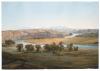
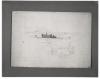
On September 11 Bodmer made another study from the hills above Fort McKenzie of what Maximilian referred to as the Bear Paw Mountains. Meanwhile, having been advised against wintering in the area, Maximilian decided to return to Fort Clark. The voyage downstream was made in a small mackinaw boat and included only Maximilian's party, a helmsman, and three Canadians.

View of the Bear Paw Mountains from Fort McKenzie

Near Cedar Island on May 16, high winds and low water again delayed the steamer's progress upstream. At this place Maximilian reckoned that the Yellow Stone had traveled a little over a thousand miles from the mouth of the Missouri above St. Louis. The ship remained stationary through May 21 above Cedar Island on a section of the Missouri now permanently flooded by the Fort Randall Dam at Pickstown, South Dakota. Bodmer's view of the river bluffs in this vicinity was made between May 19 and 21 according to an inscription that may have been added later.

View of the Bluffs near Cedar Island

Above the Ponca village the Yellow Stone reached the mouth of the Niobrara River on May 13. Later it passed a distinctive topographical feature on the banks of the Missouri called the Grand Tower. Bodmer's watercolor dated this day describes the appearance of the river, but does not present the Grand Tower as a prominent aspect of the scene.

Grand Tower on the Missouri above the Niobrara

Just after midnight on January 3, 1833, the Misssissippi steamer Homer arrived at Mount Vernon. Bodmer embarked upon it the following morning for New Orleans. During the next several weeks, he produced numerous studies of the scenery and settlements along the lower Ohio and Mississippi. Most of these are reproduced here for the first time. Bodmer's undated sketch of the Homer may have been made at any one of the stops along the course of his travels downriver.

The Mississippi Steamboat Homer

Traveling downriver from Portland, Maximilian and his party went ashore briefly when the steamer docked at Albany to repair its engines. Bodmer shot a few birds at this time and Dreidoppel dutifully prepared them as specimens for Maximilian's zoological collection. Bodmer's sketch of the Ohio reproduced here is undated; it might have been done at any time during the course of the voyage downriver.

View on the Ohio

Bodmer's unfinished sketch of the prison at Pittsburgh, made during his brief stay in that city in September, 1832, furnished the basis for the aquatint designated as Vignette VI in the atlas that later accompanied the publication of Prince Maximilian's travels.

The Prison in Pittsburgh

Maximilian planned at the outset of his journey to stop at New Harmony to visit the distinguished entomologist Thomas Say, who had accompanied Stephen Long's 1819-20 expedition to the Rocky Mountains and from whom Maximilian hoped to obtain advice concerning travel in the West. The stay at New Harmony proved longer than intended because the Prince contracted "a serious indisposition nearly resembling cholera." On October 23 and 30, he noted in his journal that Bodmer made drawings of New Harmony. It is not certain if this undated study is referred to in either case.

New Harmony, Indiana

This unfinished watercolor, made at Bethlehem during the latter part of July, depicts the landscape in the direction of Mauch Chunk, center of an important anthracite coal mining operation some fifty miles away. It includes a view of Wohler's vineyards near the inn of that name on the outskirts of Bethlehem.

The Mauch Chunk Canal: Wohler's Inn

Before sunup on July 25, Maximilian and Bodmer set out for Bethlehem, at that time a settlement of about a thousand persons located on the stage line between Philadelphia and Harrisburg. On the evening of his arrival, Maximilian met a German physician, Lewis Saynisch, who accompanied him on several outings in the area. At Bethlehem, Bodmer occupied himself with sketching various points of local interest.

View of Bethlehem on the Lehigh