Missouri River

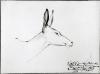
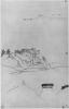
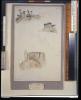
The inscription identifying Bodmer's sketch of the head of a black-tailed deer indicates that it was made on the Missouri in 1833. It does not say if the subject was observed en route to or from Fort McKenzie or above or below Fort Union

Head of a Black-tailed Deer on the Missouri

At that time the Mandans, partially in response to the pressures of raiding neighbors such as the Sioux, had consolidated their people into two villages: Mih-Tutta-Hang-Kusch and Ruhptare. Mih-Tutta-Hang-Kusch, the southernmost and largest of these, can be seen in the distance across the Missouri in this landscape, as can the stockade of the recently erected Fort Clark. Each Mandan and Hidatsa settlement maintained both a summer and a winter village. This is the summer village of Mih-Tutta-Hang Kusch.

Mih-Tutta-Hang-Kusch, Mandan Village

Maximilian and his party set out from Fort McKenzie on the morning of September 14, passing into the region of the Stone Walls again the next day. Beyond Citadel Rock on September 16, they reached the mouth of the Judith River on the afternoon of the following day. On September 18 large herds of bison were sighted in the Mauvaises Terres. Maximilian reported in his journal for this day, "Buffalo were moving today, like last night, along Dauphin's Rapid, on both banks ... .

Buffalo and Elk on the Upper Missouri

This view of Mih-Tutta-Hang-Kusch from the prairie provides a good sense of the size of the village and the dense arrangement of lodges. Portions of the partially fallen defensive palisade are again visible here, as in the river view shown in Plate 294. Just outside the palisade is a tipi, probably the camp of a visitor from another tribe. Scattered across the prairie are indications of burial scaffolds . In the foreground are high stakes wrapped with feathers and other sacred offerings or symbols.

Mih-Tutta-Hang-Kusch, Mandan Village

The strategic positioning of villages for defense purposes is evident in this view of Mih-Tutta-Hang-Kusch, located high on a promontory jutting out into the Missouri River with steep banks on three sides. A palisade surrounding the village offered additional protection, but this had fallen into disrepair at the time of Bodmer's sketch in the summer of 1833, and only a small portion of it can be seen in the drawing. Mih-Tutta-Hang-Kusch consisted of approximately sixty-five earth lodges or houses.

Mih-Tutta-Hang-Kusch, Mandan Village

On the afternoon of August 6 the keelboat approached one of the more prominent landmarks on the banks of the Missouri in the region of the Stone Walls. Lewis and Clark had described it early in the century, but did not name it. In Bodmer's day it was known among the traders as La Citadelle, or Citadel Rock, and later as Cathedral Rock. Today it is a state monument. Bodmer's view of this formation was reproduced as Vignette XVIII in the atlas of aquatints that accompanied the publication of Maximilian's travel account in 1839-43.

Citadel Rock on the Upper Missouri

On August 2, the travelers reached the first in a series of rapids on the upper Missouri. This day Bodmer sketched several formations along the bank variously designated by the letters U, V, and W. Maximilian, referring to these studies, wrote that "the bare summits are now beginning to rise ever higher, for one is now approaching the high, wild mountains which are called Les Mauvaises Terres, the principal home of the bighorns, which were found earlier, to be sure, but not in such a number."

Rock Formations on the Upper Missouri

Approximately ten miles above the mouth of the Judith River, the Arrow River, formerly the Slaughter River of Lewis and Clark, enters the Missouri channel from the south. Beyond this point the Missouri takes a decidedly northward course for some miles through a region named the Stone Walls. Approaching this area on August 5, Maximilian remarked in his journal that the keelboat was making its way through remarkably scenic country. Bodmer's study of unusual formations along the banks in this vicinity was made on August 5 or 6.

Upper Missouri

Bodmer continued sketching the unusual formations along the Missouri channel on August 2. He often incorporated more than one view on the same sheet of paper, and many were grouped together when featured in various combinations in the atlas of aquatints published in Europe. Reproduced here is a series of sketches, two of which were mentioned by Maximilian on August 2 as sketch AA and sketch BB.

Strange Sandstone Formations on the Upper Missouri

Above Fort Union, game became plentiful and hunters from the boat were successful in supplying meat for passengers and crew. On July 10, four days out from Fort Union, buffalo appeared near the river and several were taken. On July 14 near the junction of Porcupine Creek below the mouth of the Milk River, more buffalo approached the banks and a white wolf was reported in the vicinity of the herd. Bodmer subsequently produced a landscape with buffalo grazing on the Missouri bottoms that includes the figure of a white wolf skulking in the lower left foreground.

Landscape with Herd of Buffalo on the Upper Missouri

Pages