April 21, 1833
[Page 2:27]21 April: Slightly overcast sky, rain and hazy. At nine o’ clock, the warmest, brightest sunshine. We set out after dawn; one and a half hours later we stopped at the left bank and took on some wood at a settlement near wooded hills, which were turning a picturesque green. There was a mixture of green with patches of magnificently rust-red redbud; many plants were in bloom. Underneath, at its base, was a long, extended rocky bank. From this place it was about 1 mile to the mouth of the Kansas River. Twenty minutes later we reached a creek with clear, green water, and after a quarter of an hour, the mouth of the Kansas River, which has a somewhat weaker current than the Wabash and was now very low. Its clear, green water contrasted sharply in a wavy line with the brown water of the Missouri. We have sailed about 7 miles up this river with the steamboat.

Here, on the point of land between the Kansas and the Missouri, is the boundary of the United States, and one enters the territory of the free Indians. The boundary runs from south to north. Here we took on wood and waited for the boat that had stayed behind to fetch a dog. Gently sloping, wooded hills turning a beautiful green color border the Kansas; 500 to 600 paces from the mouth, one sees high yellow clay banks rising in the forest. Here along this river and, to some extent, in
the vicinity of its mouth, is the place where the Indians, driven from the eastern states, have been assigned land, and some of them are settled here. Remnants of the Lenni-Lennappé (Delawares), the Shawnees, Miamis (?), Peorias, Kaskaskias, Piankishaws, Weas, and possibly of other tribes now live here; and about 90 to 100 miles up the river are located villages of the Kansa nation, about whom Say provided us with some interesting information. The French call these people les Cans and the river along which they live rivière des Cans. The Kansa, Osage, Ponca, and Omaha languages were originally the same; Omaha and Ponca, except for a few words, completely the same. The Kansa and Osage languages are again very similar to one another in that they have a pronunciation and stress different from those of the Omahas and Poncas—otherwise, however, one and the same root. The actual habitations of the Kansa are now on both sides of the Kansas River, with its tributaries; on the prairies, they roam down to the Arkansas.
About 7 miles upstream on the Kansas, the American Fur Company has a trading[Page 2:28] post where a brother of Mr. Chouteau’ s lives. Several of his men came down to the mouth of the river; they were mulattos, or half-breeds. Formerly there were 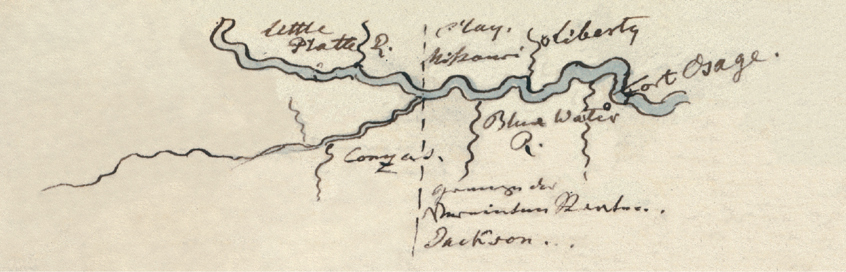 enormous numbers of beaver along this river; now they are scarce everywhere. We stopped here at the mouth for a brief half hour where the boat was navigated into the Kansas. Mr. Sanford shot two ducks from a flock with one shot of his rifle. At 7:30, 65 1/2°F [ 18.6°C]. Weather unusually warm. Finally we continued on.
Three to four hundred paces beyond the mouth, along the left bank, there is a spot on a sandbar cleared of forest [where] formerly there was a trading house for the Kansa nation; [it] has been closed. From here Mr. Pilcher had begun his furtrading ventures to the Columbia and the Rocky Mountains. He traveled through all these regions and endured great hardships, but his fur company failed and now he is going to the trading post at Council Bluff. At that [earlier] time he wanted to establish a chain of posts as far as the Columbia, something that certainly would have come about.
On the above-mentioned side, the bank of the Missouri is steep and high; excellent black soil; in the nearby woodlands, fresh vegetation and redbuds. Beautiful, violet-red phlox on the edge of the bank. Farther on, a chain of beautifully green hills arises in the forest to the left. Sandbars then follow along the bank, on which, for the first time on the entire trip, we soon saw approaching a free Indian wrapped in his woolen blanket, but we moved away too quickly. To the right on shore we once again saw piles of cut wood near a settlement. From now on, we will probably not find any more like that. Since we were in the territory of free Indians, I took my telescope in hand. To the right, a creek that came from the woodlands and tightly packed willows and cottonwoods just turning green; [creek] was now half dry. Long sandbars to the left.
Soon we were again so fast aground that our hunters could go ashore; this they did about ten o’ clock. Because we had run into a dangerous area densely filled withsnags with
snags, the ship was fastened to such a tree with a long rope; the boat remained in place. With this rope the ship was turned around, and then it steered back again, very quickly; it ran over a large tree, which broke into pieces, [and] soon over a second one, which lifted the rudder but did not damage it. In this manner we steered around the place in the river with many snags. Although we came very close to the sandbar to the left, we reached the better channel of the river and made slightly better progress. After we had passed the sandbars to the left, we reached others to the right; then we approached the left bank, the tall forest of which, filled with underbrush already half green, was overgrown on the ground with rushes (Equisetum) 1 1/2 to 2 feet high. The understory consisted primarily of spicewood; only individual redbuds bloomed here. At twelve o’ clock noon, 72°F [22.2°C]. On the right bank, Dr. Fellowes, who had gone hunting with his rifle and black frock coat, came from the forest and was already running somewhat behind us. We had to halt because of lack of water but still proceeded somewhat farther.
In the meantime we struck bottom and ran over trees in the water, soon also onto a deposit of wood, several sticks of which got caught between the paddles[Page 2:29] of the left wheel and broke to bits with a loud cracking noise; many paddles of the wheels also broke. The engine was quickly stopped, the ship pushed away, and in this way we proceeded by fits and starts. We soon ran into similar logs [and] pushed and worked the ship away from them as best we could. The wooded hill here was already very green, especially the willows on the lower part of it; individual redbuds blossomed. Soon we were again without water; the boat had to take soundings behind us; meanwhile we drifted close to the bank. One and a half hours later, after lunch and after we had found more water in the middle of the river, we sailed around the next point of land to the right.
We skirted past our hunters on the 20-foot-high bank in the forest. All the underbrush in the forest on the promontory was tinged red from redbuds; in other places there were light-green willows or green rushes; individual redbud trunks were 30 to 40 feet high. Twelve of our hunters were waiting for us 300 to 400 paces behind the promontory; we approached the right bank; some of them had gone farther ahead. Finally we saw the larger body of hunters 600 to 800 paces farther away; they had all come together there. Upon our approach [some] jumped down from the high bank, [while] others slid down a diagonally inclined tree; in all there were forty-two men. Mr. Bodmer and Dreidoppel brought a parakeet (Psittacus carolinensis), a squirrel, a young rabbit, two nice Heterodon (hognose) snakes, and several plants, as well as the blossoms of Zanthoxylum and a passenger pigeon (Columba migratoria). That snake varies greatly in its primary color. The two specimens were equally large; one had a gray-brown, the other a nearly black basic color. To the right there was now a beautiful bank; the forest was multicolored, with all kinds of young leaves and blossoms. Limestone rocks in the forest and large boulders along the bank.
The Little Platte River empties here on the right side. Along it live the Ayaways (or, as the Englishmen Americans write it, “Ioways”), 6 to 7 miles upstream. They have already been mentioned. Their language is the Otoe language. See the language samples.
The region that the Iowas inhabit and in which they hunt are the environs of the Little Platte, the Nodaway, and Nishnabotna rivers. A band of Sauks (Sacs) hunt with them in the same region. They call themselves Pa Padji (‘j’ as in French), that is, Dusty Noses, a name they received from other Indians because they lived along a sandy bank of the [Upper] Iowa, 40 miles above the Wisconsin. M41There are two Iowa rivers. The aforementioned upper one was purchased by the government. The other, which discharges below Rock Island, is inhabited by the Sauks and Meskwakis. Regarding the common origin of the Iowas, Otoes, and Missourias, who all originally came from north of the lakes, see the appendix, page 317 of this volume of the diary. The Iowas have their own agent, at the present time General Andrew Hughes, who he lives has his agency [——] miles from the Missouri and [——] miles from the Little Platte. He is only a subagent (United States Sub- Indian-Agent) and, like all the others, is subordinate to the agent, Major Dougherty.
On the left bank we now had beautiful wooded hills, dotted with young[Page 2:30] foliage and blossoms as on the Belmonte. To the right, sandbars emerge; we move over to the left. Here at a creek there was a veritable devastation of the banks. At the edge of [one] bank sat six black coots (Fulica) in a bunch [and] another one of these pretty birds on a pile of timber in the river; they were not shy. Soon afterward we ran into snags. To the rear we had a magnificent view in the beautiful, clear evening illumination; the various gradations of the elevations and woodlands were very picturesque; the majestic surface of the water gleamed beautifully. On the bank one saw several Schawano Indians (“ Shawnee ” of the Americans), who waved to us with their hands.
To the left sandbars appeared; we steered at an angle across the river toward the right bank, where the floor of the forest was overgrown with rushes. The bank is steep and high, frequently intersected with regular,  firmly trodden little pathways, which are made by game animals down to the water. Now follow ruggedly and steeply eroded shores, jaggedly brokendown banks of earth where trees hang down or are already toppled. Because we found a shoal there, we again crossed the river but soon turned back to the right bank. Many paths on the bank. An old Indian hut on the bank. It was made just like those of the Camacans on the road of Capt. Filisberto. Here the forest was wild, densely entangled with vines; red and white blossoms adorned it beautifully. In this region the Iowas and also the Meskwakis and Sauks hunt. In the vicinity of Diamond Island, we stopped for the night. Our crew then cut wood and ignited the forest with many fires, which provided a magnificent view.

