April 15, 1833
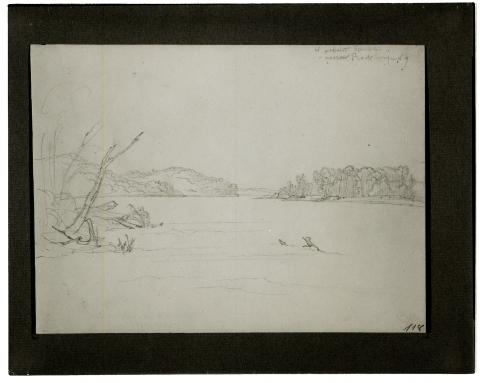
15 April: In the morning, heavily overcast sky. In the dusk we received several violent jolts. There was nothing noteworthy about the river; large sandbars. A boat sails past. The river makes a big bend, or curve; at such places there are usually islands and sandbars in the bends. Gradually sloping wooded hills and low wooded banks alternate, with borders of cottonwoods. Now to our left, a small creek; near it, a house on a hill called La petite pierre à flèche (Little Arrow Rock). The hills here form a small basin, before which there is a farm; the hills that follow are overgrown with yellow grass and have rock clusters that are not distinctive. In the river, sandy islands covered with cottonwoods. We move over [to] follow the right bank; it is wildly eroded, full of trees and rocks trunks; the rugged forest on it [is] tightly entangled with vines. Somewhat farther on, near a cultivated field, it is colored red from[Page 2:16] the redbuds; even farther on, this forest is already very green. Before us, sandy islands and bars; on one of them, someone shot at a wild goose with a rifle, and it did not fly up. Then, in about the middle of the river, we ran onto a sandbar. Before us was an island in the shape of a hat; there were tall cottonwoods in the center, a border of willows before them. Direction of the river near the island at a quarter past seven o’ clock: northeast.

After breakfast we put in at a settlement and take on wood. The buckeye tree (Aesculus) already had big leaves. Several pretty plants, including Podophyllum peltatum, which was very copious but still without flowers. Since it was somewhat early and not yet warm, most flowers had closed. The whole region here as far as the Mississippi is very fertile and heavily populated; good farms.
At 7:30, 3°R [38. 8°F, 3.8°C]. Rain as we came back on board. Boulders in the forest to the right; white Prunus blooms here copiously. To the right, several creeks, one right after the other, with a settlement. Half an hour later, the Chariton River empties to the right in an intermittently hilly, wooded region. On the river a mile upstream, the town Chariton is located; settlements at its mouth. We see and pass several islands with cottonwood, willow, and forest; rushes (Equisetum) on the forest floor; all objects are obscured by the rain. The river makes big bends and is very low. This morning we often struck bottom.
After lunch (at twelve o’ clock, temperature of [— —]) M21At noon, 8 1/2°R [51.1°F, 10.6°C]. we reached a place where the Missouri makes an enormous bend that takes us at least one and a half to two hours to get through. It is full of large sandbars, and with high water, one takes very much of a shortcut. Here the river is narrow and so full of snags that we can wind our way through only with danger. Forward, the lead is continually tossed on both sides, and we thus are able to get through—a dangerous voyage. To the right we now have an island as well as cultivated fields; the former is narrow and completely covered with a dense growth of cottonwoods. On the sandbars to the left, large deposits of driftwood. We saw wild geese on the sand and several wood ducks (Anas sponsa) to the right along the bank. Crows were flying above the forest.
When we had left the big bend behind us, we reached cornfields to the left, where the hills were partially denuded; here on the bank, perched on the withered corn stalks, we saw a flock of parakeets (Psittacus carolinensis), which we could have shot from the boat. Later we reached areas where the big sandbars have angular banks, like bastions and entrenchments, on which were enormous deposits of driftwood. The weather cleared up somewhat. Ducks on the sandbars. Remarkable destruction of the banks: in many places they were 15 to 18 feet high [and] large masses of land had slid down; the young, 30to 40-foot cottonwoods growing on them had been carried along [and] were now leaning slanted along the steep wall. Cornfields entirely torn away except for small remnants, behindwhich behind which grew tall reeds (probably Arundo phragmites) along [the] shore, now yellow and dried out. Three boys who were walking along the bank had killed a squirrel, probably Say’ s Sciurus macrourus. Frightfully devastated, steeply eroded banks to the left with devastated cottonwoods; tall reeds and grass on top.
We cut straight across, where again immense 20to 30-foot-high piles of driftwood on a sandbar provided a noteworthy sight: they formed towers, big caverns, and the like and in several places were covered with sand. They lie along the edge [Page 2:17of shoreline islands formed by narrow channels mostly blocked; ducks in pairs on the former. We followed the right bank; on the left one, there were tall cottonwoods, and before them an equally high fringe of willows. In such willows Indians formerly concealed themselves when the canoes of the whites were being pulled upriver with the cordelle; [they then] shot the people to death. Again the destruction of the banks was terrible; in June, with the next flooding of the river, this is expected to be remarkable; then the river will come roaring down wildly, with the swiftness of an arrow, between its banks, which collapse on all sides, often with tall forest trunks, floating trees, and wood in all directions, eddies, whirlpools, and a multiple current.
We moved to the right bank, which is high and steep and has black patches, because some of the black, thick humus strata on the upper surface are collapsing and create this appearance. The nearly coal-black color of the top layer of earth indicates its fertility. At five o’ clock in the evening, we reached the mouth of the Grand River, a beautiful river about the size of the Wabash but now very low. Forest and greening willows border it. At the mouth of the river, the Yellow Stone touched a sandbar and stirred up so much mud that the water turned murky and as yellow as clay. The Iowas (written “Ioways” in English) once lived up along the Grand River, until 1827, when they moved to the Little Platte River. They call the Grand River Nischna-Honjä, the Missouri Nischu-Djä (‘j’ as in French). In their language ni is “water, ” nischna is “river.”M22All the Indian languages Dougherty knows (he speaks thirteen or fourteen of them) have no general plural. For example, they never say “horses” in general but always cite a number and finally “many horses.” No genuine article exists, and these languages are very poor.
The Missouri now made a very big bend to the left, where the wood duck (Anas sponsa) was abundant along the banks. Someone shot one of these ducks; they were all in pairs. We steered over to the right bank and put in there before dusk to take on wood and spend the night. M23After we had passed Wahkonda Creek shortly before.
We immediately dispersed into the forests and the nearby homes and cultivated fields. In the latter we found a flock of parakeets, six of which Mr. Bodmer shot; [the others] did not fly away after they had been shot at. M24Regarding the tenacity of this bird see Drake, Picture of Cincinnati, page 118, where there is also information about catalpa and other natural history specimens. We also found some interesting plants, but most of them were rather late here. The elms had already formed samaras. Podophyllum peltatum had pushed out its leaves but not yet any blossoms. A squirrel was pursued without success. We all returned to the ship for supper and then carried on our usual evening occupations. The evening was cool but not unpleasant and gave promise of a nice day tomorrow.

